Antarctic ice thicker than previously thought, study finds?
Groundbreaking 3D mapping of previously inaccessible areas of the Antarctic has found that the sea ice fringing the vast continent is thicker than previous thought.
Two expeditions to Antarctica by scientists from the UK, USA and Australia analysed an area of ice spanning 500,000 metres squared, using a robot known as SeaBed.
The survey discovered ice thickness average between 1.4m and 5.5m, with a maximum ice thickness of 16m. Scientists also discovered that 76% of the mapped ice was ‘deformed’ – meaning that huge slabs of ice have crashed into each other to create larger, denser bodies of ice.
The team behind the research, published in Nature Geoscience, have hailed it as an important breakthrough in better understanding the vast icy wilderness. The findings will provide a starting point to further work to discover how ice thickness, as well as extent, is changing.
Previously, measurements of Antarctic ice thickness were hindered by technological constraints. Ice breaking ships could only go so far into ice to measure depth, while no-one had drilled much more than 5.5m down into the ice to extract a core for analysis.
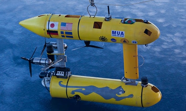
SeaBed, an autonomous underwater vehicle (or AUV), was used by the research team to analyse ice thickness at an underwater depth of 20 to 30 metres. Driven in a “lawnmower” pattern, the two-metre long robot used upward-looking sonar to measure and map the underside of sea ice floes. Oceanography robots are usually focused on the sea floor.
Dr Guy Williams, from IMAS, said the research is an important step in gauging changes to Antarctic ice.
“Sea ice is an important indicator of the polar climate but measuring its thickness has been tricky,” said Williams, the report’s co-author. “Along with the satellite data, it was a bit like taking an X-ray of the ice, although we haven’t X-rayed much of it, just a postage stamp.
“The key thing is that this is a game changer because it was previously very challenging to measure ice depth. We were limited to visual observation from the decks of ships or ice cores and take measures.
“It was a lot of hard work and quite crude, which means we were biased towards thinner ice. It was a bit like a doctor diagnosing a condition by prodding the skin.
https://www.youtube.com/watch?v=ASB7mFsQRlM
Williams said researchers will now make routine surveys of ice thickness to determine changes over a long period of time. As well as tracking alterations due to climate change, the research will be of interest to marine biologists due to the creatures, such as krill, that inhabit the region.
“This is a big step forward in our knowledge but we’ll need to have longer missions in larger areas,” he said. “What we ultimately want is a team of autonomous robots that self deploy all across the Antarctic, like the spokes in a wheel.”
Hanumant Singh, an engineering scientist at the Woods Hole Oceanographic Institution whose lab designed, built and operated the AUV, said: “Putting an AUV together to map the underside of sea ice is challenging from a software, navigation and acoustic communications standpoint.

“SeaBed’s manoeuvrability and stability made it ideal for this application where we were doing detailed floe-scale mapping and deploying, as well as recovering in close-packed ice conditions.
“It would have been tough to do many of the missions we did, especially under the conditions we encountered, with some of the larger vehicles.”
http://www.theguardian.com/environment/2014/nov/24/antarctic-ice-thicker-survey-finds

Comments
Post a Comment