This Is How global Warming Is Creating More Delays And Longer Flight Times Across The Atlantic

Flights from London to New York take longer than the other way around and it could be down to climate change according to Paul Williams, a Professor of Atmospheric Science in the Department of Meteorology at the University of Reading.
He spoke with Business Insider UK about how climate change is affecting the jet stream, particularly on flights across the Atlantic.
Read the full transcript below: http://www.businessinsider.com/climate-change-creates-flight-delays-across-atlantic-
See The Main Story Below, as point out this blog post below Jet Stream And Global Warming Do Not Meet
What causes the jet stream? |
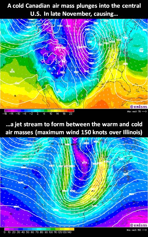
| A jet stream forms high in the upper troposphere between two air masses of very different temperature. The greater the temperature difference between the air masses, the faster the wind blows in the jet stream. This river of air has wind speeds which often exceed 100 mph, and sometimes peak over 200 mph. Jet streams usually form in the winter, when there is a greater contrast in temperature between cold continental air masses and warm oceanic air masses. The following image shows an example of this from the National Weather Service's Aviation computer forecast model: |
 |
But how does the temperature difference between two air masses cause the jet stream? Since colder air is more dense than warmer air, there is an air pressure difference between them at any altitude. And if the warm and cold air masses are quite deep, higher altitudes in the atmosphere experience progressively larger air pressure differences. Since it is horizontal air pressure differences that cause wind, this leads to very strong winds. But at some altitude high in the troposphere, the temperature difference reverses, and as you progress higher the winds then decrease. The altitude at which the winds were strongest is considered to be the jet stream level. So, the strongest jet stream winds then occur between air masses having the largest temperature differences over the deepest layer of the troposphere. Even though the wind "tries" to flow from high pressure to low pressure, the turning of the Earth causes the air flow to turn to the right (in the Northern Hemisphere), so the jet stream flows around the air masses, rather than directly from one to the other. Contrary to popular belief, the jet stream does not "cause" weather conditions of a certain type to occur. Its existence is instead the result of certain weather conditions (a large temperature contrast between two air masses). |
Interesting facts: |
AIRPLANES FLYING BACKWARDS?Just how strong the winds can be in jet streams was discovered during Word War II, when American bombers tried flying from the U.S. to Japan and found they couldn't make any progress flying against the strong winds. Today, aircraft routinely adjust their altitude to either fly with the wind in the jet stream, or move to a different altitude to avoid flying against it. |
| WORLD RECORD WIND SPEED The highest wind speed ever recorded on the surface of the Earth was 231 mph on April 12 1934, atop Mt. Washington, New Hampshire. This high-elevation weather station experienced the winds of an extremely strong jet stream that had descended to the top of the mountain. |
| (page last updated 11/29/2010) http://www.weatherquestions.com/What_causes_the_jet_stream.htm |
What causes the high-speed winds, or "jet stream," in the stratosphere? And why does the path of the jet stream wander?
James Partain, science and operations officer at the Marine Prediction Center (part of the National Centers for Environmental Prediction) in Camp Springs, Md., replies:
"The earth's atmosphere contains two major 'jet streams' (one in each hemisphere). They have considerable impact on human affairs. As we often hear during the weather segment of the nightly news, the jet streams are related to weather patterns of high and low pressure. And airline pilots are well aware of the consequences of being in or near the jet stream in an aircraft. Detailed knowledge of the jet stream--its location, altitude and strength--is therefore critical to modern-day weather forecasting, as well as to more specific applications such as the safe and efficient routing of aircraft.
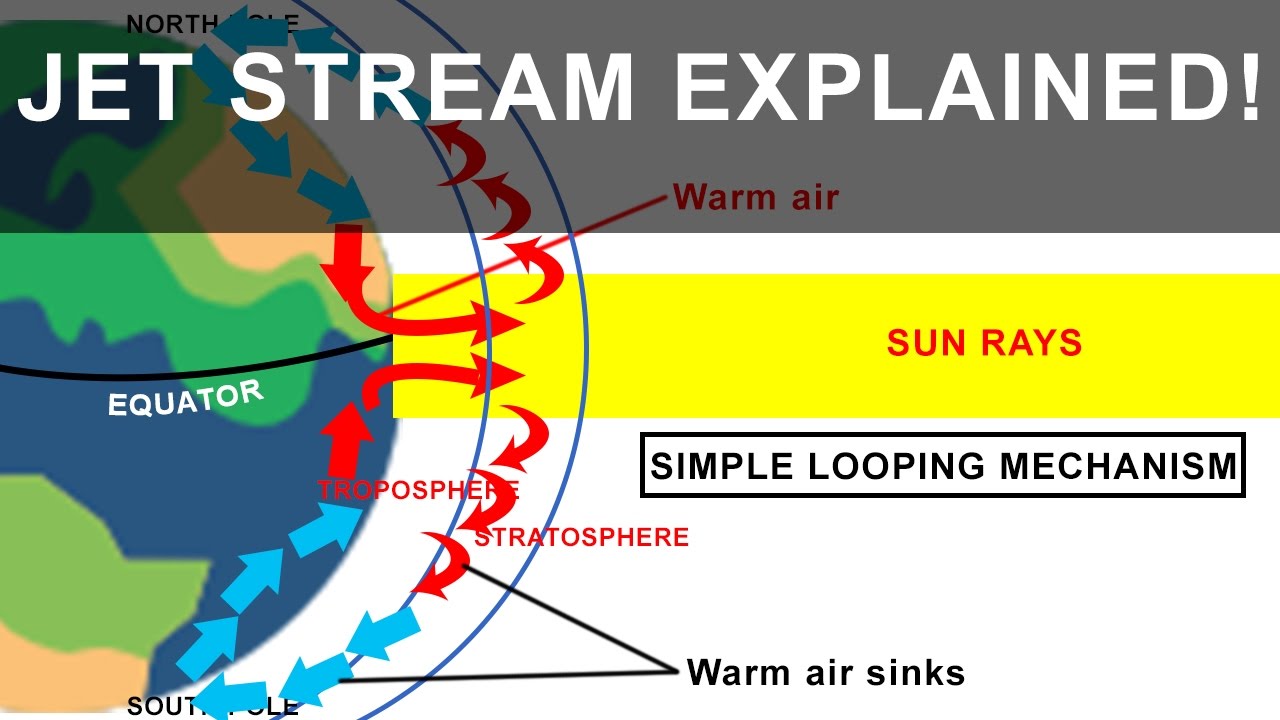
"By way of definition, a jet in fluid dynamics is simply a core (or 'stream') of fluid moving at a higher velocity than the surrounding fluid. Although they are complicated to describe mathematically, the jet streams in the atmosphere are a straightforward, natural result of the meridional (that is, equator-to-pole) temperature gradient in the earth's atmosphere. Analogous flows exist on other planets with substantial atmospheres having similar temperature gradients.
"The temperature gradient derives from the differential solar heating of the spherical surface of a planet: the surface is generally warmest at the equator and grows progressively cooler as one moves poleward. The centrifugal effects of the earth's rotation, often called the Coriolis force, deflect the north-south transport of heat from the equator to the poles into the predominantly east-west motion of the jet stream. The relative strength, or velocity, of the jet stream is proportional to the intensity of this thermal gradient. During the winter months, when the equator-to-pole temperature disparity is at its greatest, the jet stream reaches its maximum velocity. During the summer months, when the temperature gradient between the equator and the pole is considerably less (only about half the winter value), the jet stream reaches its minimum velocity.
"The altitude of the jet stream is a function of the vertical and horizontal distribution of temperature in the earth's atmosphere. You may recall that the earth's atmosphere is broken into several layers, or 'spheres.' The troposphere (in Latin, literally the 'turning' or 'changing' sphere) is the lowest layer of the earth's atmosphere, ranging in depth from around nine kilometers at the poles to around 16 kilometers at the equator. Within the troposphere, the temperature decreases with altitude, at a rate of approximately seven degrees Celsius per kilometer. Starting where the troposphere leaves off, the stratosphere (literally the 'layered' sphere) extends to an altitude of roughly 45 to 50 kilometers. Temperatures within the stratosphere increase with height, a phenomenon known as a temperature inversion. The transition between the troposphere and the stratosphere, called the tropopause, represents the coldest point of the troposphere. It is at this level, just under the tropopause, that the jet stream resides.
"As can be seen on high-altitude weather maps, the jet stream does not maintain a straight, zonal flow from west to east but rather takes on a more serpentine look, often with dramatic dips to the south or rises to the north. There are two major reasons for these nonzonal motions: the temperature gradient between the equator and the poles and the presence of land masses on the earth's surface.
"The meridional temperature gradient between the equator and poles that gives rise to the jet stream also produces secondary atmospheric circulations, or eddies. These eddies, referred to by meteorologists as 'baroclinic waves,' have a complex interaction with the jet stream. The eddies modify the distribution of temperature and kinetic energy within the atmosphere, a process that has a pronounced effect on the location and movement of the jet stream. And the jet stream itself interacts with these waves, not only as a transport or steering mechanism but also in the transfer of momentum and energy back to the waves.
"The presence of land masses on the earth's otherwise watery surface modifies the distribution of temperature, because continents heat and cool at a dramatically different rate than do the oceans. The topography of the land also influences the jet stream's location. Mountain ranges and plains on large continents, for example, significantly affect the distribution of atmospheric temperature. And since the jet stream is a thermally driven phenomenon, the more complicated the three-dimensional temperature structure of the earth's atmosphere, the more 'wandering' will take place in the course of the jet stream.
"Knowing where the jet stream will be located is essential for forecasting the movement and evolution of weather systems. The first step in the forecast process is observation. Many thousands of atmospheric observations are made each day by civilian and military aircraft, land and maritime weather reporting stations and ships and weather balloons. These observations help to define the present state and location of atmospheric circulations and weather systems, including the jet stream.
"These observational data are then plugged into numerical weather-prediction models. These models assimilate this snapshot of the present state of the atmosphere and mathematically diagnose how the jet stream and other circulations and weather systems will change with time. The output from the models is then made available to meteorologists, who apply their knowledge, experience and expertise in making the final forecast."
https://www.scientificamerican.com/article/what-causes-the-high-spee/#

Comments
Post a Comment